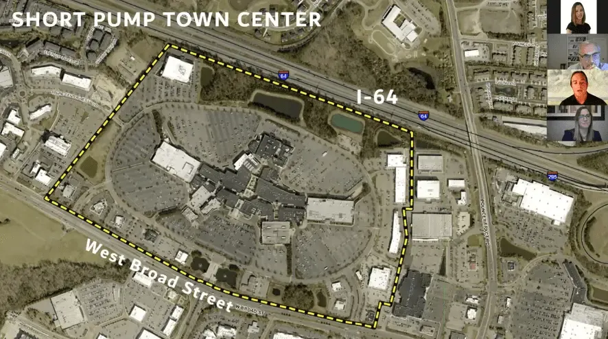
Skip to content

60 years in the making: Henrico nearing first comprehensive update of zoning, subdivision ordinance in decades

Table of Contents

Henrico’s Board of Supervisors is about a month away from approving the first comprehensive update of the county's zoning and subdivision ordinance in more than 60 years.

The board will hold a public hearing about the update June 8, then likely vote to adopt it two weeks later at its June 22 meeting.

At a work session Tuesday, Planning Director Joe Emerson told supervisors that among other goals, the proposed changes to the document are designed to:

• make the county’s regulations easier for citizens to navigate;
• make the regulations more flexible, to spur economic development by allowing for a variety of future land uses;
• update development standards;
• promote sustainable development.

County officials have amended the existing ordinance more than 300 times since the zoning ordinance was adopted in 1960, Emerson said. (The subdivision ordinance was adopted in 1955.)

Though many existing zoning classifications will remain generally the same, there will be some changes.

For example, the document proposes the implementation of new form-based zoning overlay districts in specific areas of the county as a way to encourage redevelopment according to specific standards for each while also allowing planners the authority to deviate from those requirements slightly on a case-by-case basis if they deem some impractical.

To wit: a business that wants to redevelop a site could earn approval to do so even if the location lacks the required number of parking spots, Emerson told supervisors earlier this year.

Those form-based zones would be:
• Short Pump Town Center (about which planners held a week-long charrette earlier this year as part of the process);
• the Parham Road/West Broad Street corridor;
• the Virginia Center Commons area;
• the Williamsburg Road corridor, generally between Laburnum Avenue and Airport Drive;
• the Brookfield office park area in the Near West End, between West Broad Street, I-64, Bethlehem Road and Dickens Road.

The new ordinance also would rename the urban mixed-use zoning district as the community urban use district and consolidate the OS-2 office/service district with the primary OS district.

A visual grid would allow citizens to more easily determine which uses are permissible in which zoning districts, Emerson said, and the electronic version would provide links to further explanations.

The draft changes have been through significant reviews from county staff, a community forum, volunteer and appointed committees and 12 work sessions and two public hearings before the Planning Commission.

To view the proposed documents, visit https://zoningupdate.henrico.us.

Separately during the next several years, Henrico will craft its 2045 Comprehensive Plan, a guide for future land-use decisions in the county that will serve as an update of the current 2026 plan, which was completed in 2009.

The five-phase process is entering Phase 2, during which officials will analyze community trends and conditions. VCU’s Survey and Evaluations Research Laboratory will survey 5,000 to 7,000 Henrico residents on behalf of the county (evenly split between each of five magisterial districts) to receive input about the quality of life in Henrico, an ideal vision for the future, the level of county services, possible future land uses, recreation and parks opportunities and transportation options, among other topics.

Officials don’t expect supervisors to adopt the plan until sometime in 2024, though a contractual schedule shows that adoption occurring in the summer of 2023. But, said Emerson during Tuesday's work session, “What you see in front of you is a perfect-world scenario, and that’s not what happens.”